Rain hits L.A. amid worries of mudslides; Malibu schools shut; I-5 closed at Grapevine

- Share via
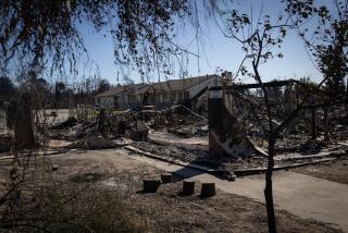
Los Angeles County’s first significant storm in more than eight months has already forced the closure of the 5 Freeway at the Grapevine, unleashed mud on roadways, and triggered the closure of Malibu’s public schools Monday due to dangerous road conditions.
There’s still concern about the potential for mudslides and rockslides in L.A. County areas recently burned by wildfire. Before 4 a.m., a severe thunderstorm capable of producing waterspouts and hail was detected near Catalina Island.
The National Weather Service has issued a flood watch for several recently burned areas, warning of a 10% to 20% chance of significant flash flooding and debris flows capable of damaging roads and homes in and around areas devastated by wildfires.
Here’s what you need to know:
Impacts
Interstate 5 at Grapevine shut down
Interstate 5 was closed at the Grapevine — the key section of roadway through the Tejon Pass that connects Los Angeles County with the Central Valley.
The Grapevine was ordered shut late Sunday night, and crews were “working to clear snow,” the California Department of Transportation said. Caltrans on Monday morning suggested using U.S. 101 as an alternate route between Los Angeles County and Central California.
“The closure will be in place for an unknown duration,” the California Highway Patrol said.
For several hours, part of U.S. 101 was also closed Monday morning. In downtown Los Angeles, the southbound lanes were shut down at 4th Street until about 6 a.m. overnight due to flooding, according to the California Highway Patrol.
Residents who lost their homes in the Palisades and Eaton fires can now sign up for toxic debris removal on the county’s website.
Malibu public schools closed on Monday
The Santa Monica-Malibu Unified School District announced all four of its Malibu schools are closed Monday due to dangerous road conditions and challenges accessing the schools. Public schools in Santa Monica remain open.
Pacific Coast Highway affected by flooding
Part of Pacific Coast Highway was closed due to flooding in Topanga Canyon, National Weather Service meteorologist Joe Sirard said Sunday. A rain gauge picked up 0.74 of an inch on Topanga Canyon Boulevard on the edge of the fire boundary, he said.
Mudflows forced the closure of Pacific Coast Highway west of Topanga Canyon Boulevard, Caltrans said Sunday afternoon.
Caltrans’ QuickMap website said early Monday that the northbound Pacific Coast Highway remained closed at Topanga Canyon Boulevard, and southbound PCH was closed from the Sweetwater Canyon Road.
Topanga Canyon Boulevard, also known as California 27, is closed. The rains caused Topanga Creek to overflow, and debris covered the roadway. Crews that were fixing damage from the Palisades fire had to evacuate, Caltrans said.
After an epic dry streak, the first real rain of winter fell in Southern California, bringing elevated risk of floods and landslides to areas recently burned by wildfires.
Vehicles trapped in mud
Four vehicles were trapped in mud along Mulholland Drive, around the 4100 block of Alhama Drive in Woodland Hills, on Sunday evening.
No one needed to be rescued, the Los Angeles Fire Department said, but officials did summon tow trucks to remove the trapped vehicles.
Movement of mud and ash from burned areas
Officials at a Pacific Palisades town hall said the Los Angeles Fire Department was working to remove mud that had accumulated on Palisades Drive on Sunday evening and that black ash-laden water had reached the beach.
White-out conditions in the high desert
Caltrans said a section of eastbound California 138 — in Los Angeles County’s high desert — was experiencing white-out conditions due to heavy flurries. Caltrans said to avoid California 138 between the San Bernardino County line to the junction with California 18.
Snow at the Cajon Pass
The California Highway Patrol said snow was falling at the Cajon Pass — the mountain pass that connects the San Bernardino area to the Mojave Desert.
Caltrans plows were plowing Interstate 15, the CHP said.
“If you’re traveling, slow down, increase distance, and expect delays,” the CHP said.
After an epic dry streak, the first real rain of winter fell in Southern California, bringing elevated risk of floods and landslides to areas recently burned by wildfires.
Concern about mudslides in recently burned areas
Flood watch for burned areas
A flood watch is set to continue through 4 p.m. Monday for the burned areas of the Eaton fire in the Altadena and Pasadena areas; the Palisades and Franklin fires in the Pacific Palisades and Malibu areas; the Hughes fire around Lake Castaic; and the Bridge fire in the San Gabriel Mountains west and southwest of Wrightwood.
There’s a 15% to 25% chance of thunderstorms over a wide swath of Southern California through Monday afternoon, which can bring heavy rainfall, and with it, the risk of mudslides and debris flow.

A debris flow can happen when water rapidly flows downhill and, besides mud, picks up rocks, branches and sometimes boulders — something capable of damaging cars and homes. It can be life-threatening.
How much rain and snow has fallen
Rainfall
Downtown L.A. has so far received 0.47 of an inch of rain from this storm, including 0.11 of an inch on Saturday.
Saturday’s rainfall alone breaks a record dry spell for downtown Los Angeles. The last time downtown got one-tenth of an inch of rain or more on a single calendar day was May 5, when 0.13 of an inch of rain fell.
That means, starting May 6 through Friday, downtown L.A. has spent 264 consecutive days without seeing at least one-tenth of an inch of rain on a single calendar day. The last record of this kind for downtown was 253 consecutive days, from Feb. 25, 2008, to Nov. 3, 2008.
After an epic dry streak, the first real rain of winter fell in Southern California, bringing elevated risk of floods and landslides to areas recently burned by wildfires.
Here’s how much rain has fallen during this rainstorm, through 10 p.m. Sunday:
Fillmore: 1.36 inches
Pepperdine University: 1.15 inches
Thousand Oaks: 1.13 inches
Calabasas: 1.06 inches
Ventura: 1.02 inches
Santa Monica Pier: 0.98 of an inch
Northridge: 0.97 of an inch
Bel-Air: 0.93 of an inch
Canoga Park: 0.9 of an inch
Beverly Hills: 0.83 of an inch
Claremont: 0.56 of an inch
La Cañada Flintridge: 0.53 of an inch
Downtown Los Angeles: 0.47 of an inch
Whittier: 0.45 of an inch
Alhambra: 0.4 of an inch
Culver City: 0.2 of an inch
Snowfall
Heavy snow was expected in the eastern San Gabriel Mountains, with total snow accumulations of up to 14 inches, the weather service said. Snow levels could drop to 3,000 feet above sea level into Monday.
Travel in and around Mt. Baldy, Wrightwood, Mt. Wilson and along the Angeles Crest Highway “could be very difficult to impossible,” the weather service said Monday morning.
Rodney Nickerson had lived in Altadena since 1968, when he bought his three-bedroom house on Alta Pine Drive with $5 down. The 82-year-old military veteran and church deacon received no warnings to evacuate before the Eaton fire swept through his neighborhood, his daughter said.
Where L.A. stands in terms of its seasonal rainfall
Downtown L.A. has now seen 0.63 of an inch of rain since Oct. 1. That’s a drop in the metaphorical bucket of how much downtown on average gets at this point in the season — 6.66 inches. That’s about 9% of the average.
Before this weekend’s rain, the extraordinary dry start to the water year was ranked as the second worst in downtown L.A.’s record books.
The extraordinarily dry conditions have kept vegetation flammable, an explosive combination during strong Santa Ana wind events that can rapidly spread embers if a fire breaks out.
‘Mom, are we going to have to run?’ Here’s how the first 24 hours of our unprecedented conflagration unfolded across L.A. County
Weather outlook after this storm
Light showers are expected over L.A. and Ventura counties by the late afternoon. There’s a chance of partly cloudy skies late in the afternoon for most areas, the weather service said, and the storm is expected to be mostly gone by late Monday.
On Tuesday, there’s a slight chance of afternoon showers in the San Gabriel Mountains.
Forecasters then expect dry weather later in the week. The weekend could bring clouds and a slight chance of rain, although mainly to San Luis Obispo and Santa Barbara counties, the weather service said.
More to Read
Sign up for Essential California
The most important California stories and recommendations in your inbox every morning.
You may occasionally receive promotional content from the Los Angeles Times.


