Intense, localized downpours possible into Monday in L.A.; how much rain has fallen so far?

- Share via
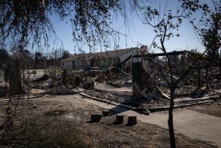
Although rains are expected to subside Sunday evening into Monday, flash-flood and mudslide risks for the wildfire burn scar areas will persist through Monday afternoon, according to the National Weather Service.
The rainstorm’s center is expected to move over L.A. County on Monday, creating the highest risk of intense, localized rainfall throughout the day. Ahead of the storm, the National Weather Service issued flood watches for the Palisades, Eaton, Hughes, Franklin and Bridge fire burn scars.
At a town hall Sunday, officials told those affected by the Palisades fire that the county Department of Public Works had installed 15,000 K-rail barriers and 50,000 sandbags in the burn area to protect properties and the environment.
High-intensity rain — more than half an inch per hour — can wreak havoc on burned areas, increasing the likelihood of flooding and landslides on soil made water-repellent by fire. Rainfall rates of 0.39 inches per hour were reported near Pepperdine University, with higher rates likely occurring, said the service.
At 7:40 p.m. Sunday, the National Weather Service elevated the flood watches for the Franklin fire burn scar and the western portion of the Palisades scar to a flash flood warning, the highest level of alert for possible floods, until 11 p.m. The service warned mud, rock and debris flow will impact drainages, roads and residences, and — while not immediately likely — life-threatening debris flow is possible.
The flood watches are set to expire at 4 p.m. Monday.
Rain across the region has been extremely variable, with parts of Los Angeles receiving more than an inch of rain by 7 p.m. Sunday and other areas receiving less than a tenth of that, according to the National Weather Service.
A National Weather Service station at Eaton Dam, near the Eaton fire burn scar, recorded 0.13 of an inch of rain. A Monte Nido station — in the Santa Monica Mountains near the Palisades fire burn scar — recorded 0.55 of an inch.
Mountains in Greater Los Angeles had received 1 to 5 inches of snow by Sunday morning, and a National Weather Service spokesperson said the Oxnard office was aware of social media reports of hail near Ventura.
Here are the National Weather Service rainfall totals for the last 48 hours as of 7 p.m. Sunday:
Metropolitan
- Monte Nido: 0.55 of an inch
- Bel Air: 0.93
- Culver City: 0.20
- Beverly Hills: 0.82
- Hollywood Reservoir: 0.84
- South Gate: 0.29
- La Habra Heights: 0.31
Valleys
- Agoura: 0.33 of an inch
- Chatsworth Reservoir: 0.66
- Canoga Park: 0.59
- Sepulveda Canyon: 0.89
- Hansen Dam: 0.87
- Newhall-Soledad School: 0.55
- Saugus: 0.41
- Del Valle: 0.61
San Gabriel Valley
- L.A. City College: 0.39 of an inch
- Eagle Rock Reservoir: 0.55
- Eaton Wash at Loftus Drive: 0.39
- Mt. Olive High School: 0.52
- Eaton Dam: 0.13
- Puddingstone Diversion Dam: 0.87
- Santa Fe Dam: 0.37
- Whittier Hills: 0.38
- Claremont: 0.48
More to Read
Sign up for Essential California
The most important California stories and recommendations in your inbox every morning.
You may occasionally receive promotional content from the Los Angeles Times.


