After this week’s heatwave, there’s relief in sight for Southern California
- Share via
An upper-level high bringing heat to Southern California through Sunday is expected to weaken and move away from the state Monday through Thursday, the National Weather Service said.
A weak upper-level trough will replace the high, bringing a return of onshore flow, with gradual cooling and more marine layer.
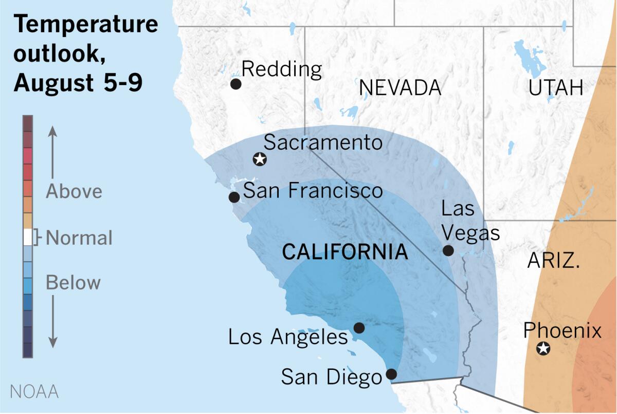
Extended outlooks from the National Oceanic and Atmospheric Administration’s Climate Prediction Center show below-normal temperatures favored for Southern California in early August.
Summer heat generally peaks during the last week of July in many places across the United States. The expression the “dog days of summer” refers to the period from July 3 through Aug. 11, which encompasses the 20 days before and the 20 days after the star Sirius appears. Sirius comes from a Greek word that means “glowing” or “scorching,” and it is the brightest star in the constellation Canis Major, which means large or greater dog.
Since antiquity this star has been associated with the part of summer in the Northern Hemisphere when heat and the resulting discomfort are at their peak.
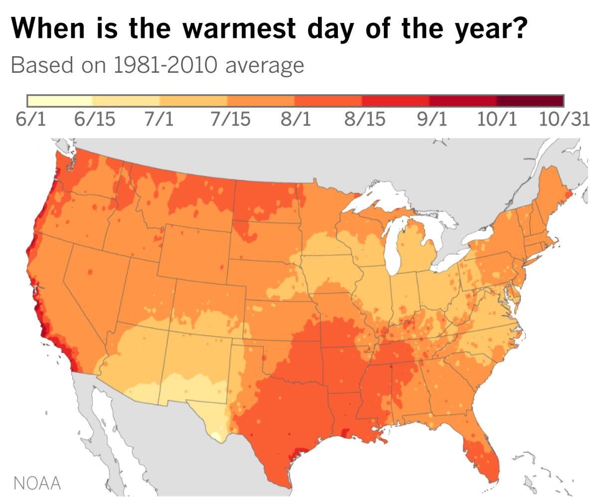
In most of the United States, the warmest day falls roughly between the middle of July and the middle of August. Solar radiation reaching the Earth is at its maximum in the Northern Hemisphere on the summer solstice, which was June 20 this year. That’s the point when the Northern Hemisphere is tilted the most toward the sun. But temperatures continue to rise for several weeks because the heat input from the sun continues to exceed the cooling that occurs at night. This goes on until temperatures eventually begin to decline in late July and early August.
But as Jan Null of Golden Gate Weather Services points out, some locations in California wait until August or September for their hottest weather. San Francisco, said Null, is the latest of any major U.S. city in this respect. The fog-shrouded city reaches its normal highest maximum temperature of 70.4 degrees on Sept. 24. San Jose, 40 miles to the southeast, is one of the earlier cities, peaking at 83.8 degrees on July 10.
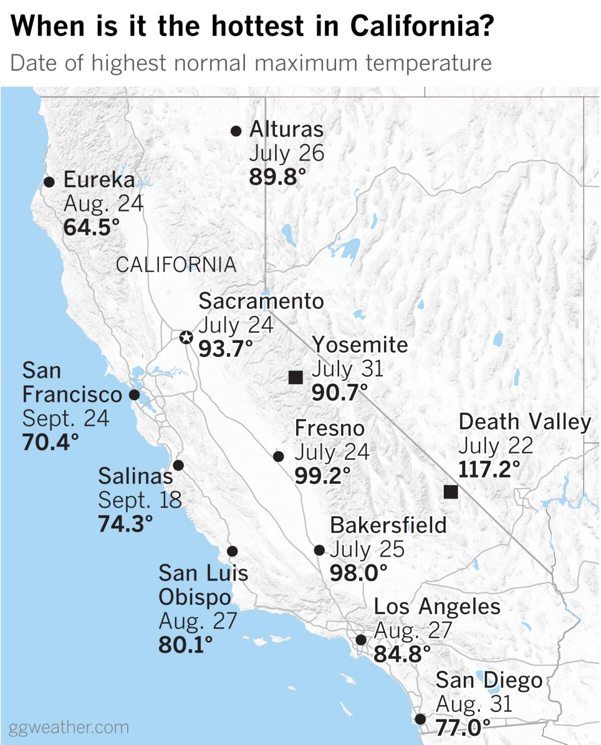
Cities in the Central Valley such as Redding, Sacramento, Fresno and Bakersfield follow the late-July rule of thumb and peak on either July 24 or July 25. Death Valley peaks on July 22, and Yosemite is on July 31. Riverside dawdles until Aug. 3, when it reaches its normal highest maximum temperature of 94.6.
Over on the coast, Eureka finds its peak on Aug. 24. Los Angeles holds off until Aug. 27 and San Diego makes the end of the month, coming in on Aug. 31.
Salinas reaches its peak of 74.3 degrees on Sept. 18, and then San Francisco chimes in two months after the typical late-July peak for so many localities.
The persistent marine layer at the coast is responsible for holding temperatures down earlier in the summer, but then the fog lifts in late summer and early fall.
In San Francisco, the dog days are still barking when the frost is already on the pumpkin in some parts of the country.
More to Read
Sign up for Essential California
The most important California stories and recommendations in your inbox every morning.
You may occasionally receive promotional content from the Los Angeles Times.

