Call us crazy; you’d be right
MICHAEL Visbal’s home is a three-bedroom, three-bath monument to denial.
Perched near the top of Malibu’s Serra Retreat — a Shangri-La where homes have names and plenty of breathing room — the smallish blue house with great big views sits on a steep slope held up by 16 steel beams.
“It’s worth the risk to have a slice of paradise,” he says. And he means it. Last year’s rains nearly sent the place tumbling into the canyon. And still, he has no plans to budge.
A lot of people would say he’s crazy. But not here. Southern Californians are in love with a region that doesn’t always love them back. We’re enamored of flood plains that lie in the shadows of mountains and quaint towns that straddle fault lines. Santa Ana windstorms howl through the picturesque canyons, fueling fires on parched hillsides.
Yet, for more than a century, we have put up with all of it, like the spouse of a philandering mate who forgives and forgets. Neither the great floods of 1938 and 1969, nor the historic quakes of 1857, 1933, 1971 and 1994, nor the apocalyptic fires of you-name-it have deterred buyers from settling in the Southland’s calamity-prone hills and valleys.
“The California Dream is so much more powerful than any potential perils,” says Cal State Fullerton geography professor John Carroll. “It’s easy to put disasters out of our minds.”
Disaster amnesia, as social historian Mike Davis calls it, is the primary psychological tool that allows Southern Californians to build and rebuild on porous, scorched and flooded land. Talk to fire survivors and they’ll tell you that they feel safest in the three years after firestorms, when the hills and canyons are stripped of vegetation and local governments step up fire-safety regulations. Then when that window closes, they tell themselves that lightning never strikes twice.
The triumph of emotion over reason isn’t a new development in real estate. There’s Boston’s Back Bay, once an expanse of mudflats and drained by the city fathers in 1825 for more real estate to build on. And then there’s New Orleans. And San Francisco.
“People don’t bring to the forefront historic considerations,” said Yorba Linda geotechnical engineer Greg Axten. “They look at homes with rose-colored glasses, and they shield out important information.”
Axten once had a client who wanted to buy in Rolling Hills’ “Flying Triangle,” a fitting name for the area on the Palos Verdes Peninsula given the instability of the land.
Axten saw a crack developing on the ground in the neighborhood and a small fissure in the corral behind the house. Nonetheless, the client began the purchase process. In the middle of the paperwork, the house moved about 10 feet. Alarmed, the client burst into Axten’s office, shaking, in a cold sweat, and asked what he should do.
“I all but told this guy not to buy the house,” Axten recalled.
A week later, the client did buy the house, persuaded by a $60,000 seller discount. The home continued to slide. And Axten still shakes his head over it.
“There was no rational reason for this guy to make that deal.”
*
Really, really attached
What motivates us to buy, when the risks are so great and so obvious?Psychologists call it “place attachment,” the deep emotional bond homeowners develop for their natural environment, deeper even than ties with their neighbors and schools, said Anastasia Loukaitou-Sideris, chairwoman of UCLA’s urban planning department.
The connection to the land makes it emotionally difficult to leave an area and prompts irrational decisions to rebuild in neighborhoods recently ravaged by fires and floods.
About 75 miles down the coast from where Visbal is installing a 200-foot retaining wall, sinking more than a dozen 50-foot steel beams that are bolted to rock 100 feet beneath his home, Lars Roulund stood on an upper deck at his Bluebird Canyon home in Laguna Beach and contemplated his own landslide last winter, which nearly swept away his 3,000-square-foot house. He remembered the lower deck cracking beneath his feet, the sides of his house sliding down the hill, the fissures in the land, the city issuing an emergency permit and a drilling crew shoring up the sinking property just days after it started slipping.
“Although there were times when I thought the magic left the house and I wanted to sell it, the magic is back now,” Roulund said. “I have no regrets, no second-guessing; I’d do it all over again without question.”
Randall Bell, a Laguna Beach real estate appraiser with extensive disaster experience, is not surprised by that attitude. He says it’s a rare fire or landslide client who does not rebuild.
Not only that, homeowners who lose their houses to those calamities often rebuild closer to the ocean or higher on a hill in a known fire zone. It helps if money is no object, but even those who have to struggle to rebuild often do so.
“Most people would give their right arm to live anywhere along the coast,” Bell said. “I call it the ‘Malibu Factor’: The area has floods, fires, wave damage that destroys beachfront homes, and without blinking, people rebuild.”
The lure to Southern California’s coastal areas began after World War II, when the brand-new freeways connected the burgeoning population to remote areas where the air was cleaner, the views were spectacular and building regulations were scarce. These new residents quickly changed the landscape, said historian Philip Radkin, bringing flammable vegetation and, with it, disaster to the hills.
“Los Angeles has put itself in harm’s way,” social historian Davis writes in “Ecology of Fear.” “Historic wildfire corridors have been turned into view-lot suburbs, wetland liquefaction zones into marinas, and flood plains into industrial districts and housing tracts. As a result, Southern California has reaped flood, fire and earthquake tragedies that were avoidable.”
There’s knowing about earthquake risk and hoping it will stay at arm’s length. And then there’s rolling out the welcome mat and making it your best friend.
Kris and Andy McCurdy are 22-year mountain dwellers who three years ago bought a house in Wrightwood that straddles the San Andreas Fault, the 800-mile-long fracture that brought San Francisco to its knees in 1906. Although there have been at least 117 major earthquakes within that fault’s system since 1769, the McCurdys don’t worry about the oft-predicted Big One.
And why should they? The last time the San Andreas Fault rattled the area hard was in 1857, when the 8.0 Fort Tejon temblor shook the nearby Cajon Pass. Some residents of this San Bernardino County resort community live in 100-year-old cabins that withstood the Whittier Narrows and Northridge quakes.
Kris McCurdy, the former mayor of the town and a real estate agent’s assistant, has an “earthquake box” ready, with a can opener, water and an emergency blanket. And the Mountain High ski resort has large generators, in case the electricity goes out, McCurdy said.
And if the earthquake swallows the house that rests on the largest fault in California?
“I never worry about that,” McCurdy said. “We feel more secure up here than you guys do down below. We don’t have exposed power lines or freeway overpasses or big buildings or swimming pools. I just don’t think about it at all.”
*
Hillside scourge
Of all the natural disasters that befall Southern California, fire is the one that hillside homeowners dread the most. They are as predictable as the Santa Ana winds that gust into canyons each fall and as capricious in their destruction as tornadoes on the Great Plains.Carole and Tom Baskerville still shudder when they recall the Malibu inferno of 1993, which destroyed more than 250 homes. The sound of choppers dropping water on their Las Flores Canyon neighborhood. Neighbors’ houses up in smoke. Their evacuation with two cars, two beagles, family photographs. The fleeing deer. The ride down the hill, flames licking the side of the road, not knowing if their house would be standing the next day.
“We knew there was a risk when we bought in 1984, but we couldn’t resist the seduction of the blue ocean, the views,” Tom Baskerville said.
Their house, atop the wind-swept canyon, came with a concrete roof, which the couple thought was a fire safeguard. They cleared brush every year, but as surely as the sun sets each day out their picture window, fire swept into the canyon that late October, scorching a wide swath of the Santa Monica Mountains, including the edge of the Baskervilles’ property.
Their neighbor, Ron Abel, made it back to his house through a gantlet of barricades and, with his son, hosed down his house and the Baskervilles’. But the house across the street was not spared. It burned to the ground.
And it was rebuilt by the owner.
*
(INFOBOX BELOW)
And it just keeps on coming ...
1889-90, flood: Thirty inches of rain in 20 days washes out nearly every bridge in L.A.
1889 and 1909,La Conchita
landslides:
The ’09 slide buries the Southern Pacific rail line and a train.January 1914, flood: The flow of the Los Angeles River rivals that of the Colorado, causing $10 million in damage.
March 12, 1928, St. Francis Dam bursts: A 180-foot wall of water roars 65 miles down the Santa Clarita Valley to Oxnard. 450 dead; $59 million in damage.
March 10, 1933, Long Beach earthquake: The 6.3-magnitude temblor leaves 115 dead, making it the second-most deadly California quake in history; $45 million in damage.
Jan. 1, 1934, flood: La Crescenta, Montrose and Glendale hardest hit; 40 dead; 640 homes damaged or destroyed.
March 1938, Los Angeles River flood: After five days of rain, the flood left 115 dead; 5,601 homes destroyed, 1,500 uninhabitable.
Thanksgiving Day 1938, Topanga Canyon fire: 350 homes are destroyed.
September 1939, tropical storm: Rains and 65-mph winds leave 45 drowned.
August 1956,Rancho Palos
Verdes landslide:
Road construction triggers 270-acre slide, destroying 120 homes.January 1952, flood: More than 3 inches of rain in 24 hours leaves eight dead, thousands evacuated and 1,000 cesspools collapsed and overflowing in the San Fernando Valley.
February 1962, flood and landslides: Torrential rain brings landslides. 21 deaths, millions in damage, mud hubcap-deep on Hollywood Boulevard.
Nov. 6-7, 1961, Bel-Air/ Brentwood fire: 6,090 acres consumed; 484 homes destroyed.
Dec. 14, 1963, Baldwin Hills Dam failure: A 50-foot wall of water plows into the community below; five dead, $50 million in damage.
Winter, 1969,storms and
landslides:
Southern California’s worst storms in 31 years: 91 dead, 6,000 evacuated, $56.8 million in damage.Sept. 25, 1970, Chatsworth/
Malibu fires:
Destroy 170 homes and structures.Feb. 9, 1971,San Fernando
earthquake:
A 6.7 temblor kills 65; $550 million in damage.Feb. 10, 1978, severe storm, flash floods: Eleven dead; 30 bodies washed out of the Verdugo Hills Cemetery; about $43 million in damage.
Oct. 2, 1978, Bluebird Canyon landslide: 60 homes destroyed or damaged; $17.6 million in damage.
Winter 1978, Abalone Cove landslide: 600 acres of the Rancho Palos Verdes move, destroying at least 45 homes.
April 13, 1979, Big Rock rockslide: $372-million Pacific Coast Highway slide.
February 1980, flood: Nine days of storms leave 24 dead, seven missing, 110 homes destroyed, 1,350 damaged and 3,000 to 5,000 evacuated in Riverside County.
storms, 3.5
earthquake in Inglewood and
tornado in South-Central Los
Angeles:
At least five dead from the storm with 2,000 evacuated from O.C. and $7.5 million in damage to the Santa Monica and Seal Beach piers; from the twister: five homes destroyed, 58 damaged and at least $15 million in damage to South-Central.Oct. 1, 1987, Whittier Narrows quake: The 5.9 temblor east of downtown L.A. leaves eight dead, $358 million in damage to 10,500 homes and businesses.
Feb. 10, 1992, rainstorm and flood: The L.A. Fire Department rescues 48 motorists caught in a flood on Burbank Boulevard; eight dead, $125 million in damage.
Winter 1993,floods, O.C.
tornado:
Rains cause flooding, mudslides and an enormous sinkhole on Fairfax Avenue in L.A.; dozens rescued.November 1993, wildfires: 194,000 acres burn in Southern California and leave three dead and 12 injured, 618 homes destroyed, $719 million in damage.
Jan. 17, 1994,Northridge
earthquake:
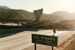
The 6.7 temblor, largest in the history of the metropolitan area, kills 57, destroys or damages 200,000 homes and leaves 20,000 homeless. Fuel lines burst, igniting fires. $20 billion to $40 billion in damage, second-costliest disaster in the U.S., after Hurricane Katrina.January 1995, floods: Eleven dead; $300 million in damage statewide.
March 4 and 10, 1995,La
Conchita landslides:
Fourteen homes in the Ventura County community severely damaged.Fall-winter 1997, El Niño storms and floods: Rock and mudslides; eight dead; highway closures; $12.4 million in O.C. property damage.
Winter 1998, floods: Three dead; 230 L.A. County traffic accidents in one four-hour period; $400,000 in damage to Hueneme Pier due to 18- to 20-foot waves; $475 million in damage statewide. More than 37,000 L.A. County residents apply for federal-disaster aid.
October 2003, wildfires: From Ventura County to the Mexican border; 24 dead, 3,631 buildings damaged or destroyed.
Jan. 10, 2005,La Conchita
landslide:
10 dead; 36 homes destroyed or damaged.June 1, 2005, Bluebird Canyon landslide: The Laguna Beach slide destroyed or damaged 20 homes.
2006, so far, so good.
Sources: Los Angeles Times archives, the U.S. and California Geological Surveys, city of West Covina
More to Read
Sign up for Essential California
The most important California stories and recommendations in your inbox every morning.
You may occasionally receive promotional content from the Los Angeles Times.


