Angeles Crest Highway closures cause confusion and frustration
With a small day pack strapped to his back, Scott Groves set out from his home in Pasadena to the foot of the Mt. Wilson Trail in Sierra Madre. He climbed seven miles to the top of the mountain and then proceeded down Mt. Wilson Road before happening upon the closed portion of Angeles Crest Highway.
“It wasn’t even on my radar that this was closed,” Groves said as he stopped to fill his water pouch near the intersection of Angeles Crest and Angeles Forest highways. “I had read that it was clear to come up from the Palmdale side, so I figured everything here was cool.”
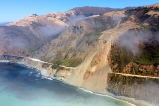
About 20 miles of the 66-mile Angeles Crest Highway, from La Cañada Flintridge to Mt. Wilson Road and 25% of the Angeles National Forest remain off-limits to the public as construction crews rebuild pieces of the route that winter storms caused to wash out. The $16.5 million in repairs, contracted out to Thousand Oaks-based Burns Pacific Construction, is expected to be completed in November.
Meanwhile, the closures continue to frustrate and confuse those seeking to access some of the most popular portions of the San Gabriel Mountains. Hundreds of motorcyclists, bicyclists and hikers have been spotted in restricted areas, according to officials from the California Department of Transportation and U.S. Forest Service. Some of the trespassing seems to be due to genuine misunderstanding about the status of different portions of the road and forest.
In late June, Caltrans Public Information Officer Patrick Chandler intercepted a dozen members of a family setting off on a hike.
“They parked at Angeles Forest Highway where it meets Angeles Crest and walked up to the closure and were going to go down to Switzer Falls,” Chandler said.
He had to explain to the family that the popular trail was closed. But hikers have not been alone in their confusion: Road repair workers reported that Los Angeles County public safety personnel have attempted to respond to emergency calls by traveling north on Angeles Crest Highway, only to hit roadblocks.
Los Angeles County Fire Battalion Chief Mitch Brookhyser confirmed one such incident. On May 31, units from La Cañada Flintridge’s Station No. 82 responded to a call of a motorcycle that had gone off the side of Angeles Crest, Brookhyser said. The responders were forced to stop at a locked gate. The call was canceled minutes later, he said.
Many of those entering closed portions of the highway and forest, however, are doing so with overt disregard for clearly posted signs, Chandler said. A Las Vegas motorcycle crew posted on its blog a dozen photos of members circumventing closures and being cited by the California Highway Patrol during an outing in May.
And on a recent afternoon, Jim Blake, a Lake View Terrace resident and avid bicyclist, stopped to watch workers repair a 200-foot-deep washout near Brown Canyon — the largest of the two dozen damaged spots. He had pedaled 27 miles, traveling on Big Tujunga Canyon Road, Angeles Forest Highway and Angeles Crest Highway.
“Big Tujunga Canyon was open,” Blake said. “Then they had some signs on Angeles Forest Highway that it was closed ahead, but cars could go through. At Angeles Crest Highway they had a gate, but I could get through there.”
He enjoyed having the road to himself, Blake said, although he did have to steer clear of a couple of dump trucks.
More to Read
Sign up for Essential California
The most important California stories and recommendations in your inbox every morning.
You may occasionally receive promotional content from the Los Angeles Times.


