Hurricane Forecasters Look Beyond the Horizon
- Share via
MIAMI — It was Friday the 13th, and over the warm waters of the Gulf of Mexico, nature was preparing another nasty reminder of how hurricane forecasting remained an approximate science.
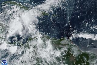
What had started as Tropical Depression No. 3 southeast of the Caribbean island of Grenada was now a hard-charging spiral of wind and rain named Hurricane Charley. After damaging 11,000 homes in Cuba, the storm was bearing northward and was expected to strike Florida, possibly near heavily populated Tampa Bay.
Charley, however, was performing according to its own script.
By early that afternoon, aircraft reconnaissance and satellite and radar data pouring into the National Hurricane Center west of Miami showed that the storm -- its winds growing stronger -- had taken an unexpected jog eastward. When it plowed into Florida’s Gulf Coast south of Tampa, the hurricane was a Category 4 on the five-level intensity scale. Spinning off wind gusts as high as 180 mph, Charley destroyed more than 2,100 homes in Charlotte County and damaged more than twice that many.
“We missed it by a category,” Max Mayfield, the meteorologist who runs the hurricane center, said later. On the other hand, Mayfield said, a day before Charley’s August landfall, his meteorologists had predicted the course within 45 miles. “The truth is,” Mayfield said, “the track forecast was pretty good.”
The art of predicting where hurricanes will go and what they will do has made astonishing advances since Benjamin Franklin first tried to penetrate their mysteries in Colonial America. Still, the powerful storms -- which can total a million cubic miles of whirling wind, clouds and rain -- can change in direction or intensity quickly, as Floridians were reminded this summer.
“Nobody predicted [Hurricane Charley] would go from Category 2 to Category 4 in four hours,” said Wayne Sallade, director of emergency operations in Charlotte County.
Tiruvalam N. Krishnamurti, a Florida State University professor who has developed one of the latest hurricane-behavior formulas, said that to make more accurate predictions, “we need bigger computers, more fine-resolution models -- and lots more observations.”
To build a more dependable forecast, meteorologists said, they also need a better understanding of how a hurricane interacts with surrounding water, air and land. “There are lots of things we can do,” said Robert Gall, lead scientist of the U.S. Weather Research Program in Boulder, Colo. “We’re just not quite there yet.”
Radar, chase planes and weather satellites have given forecasters the ability to see beyond the horizon. And since the 1970s, a succession of computerized models has been used to predict a hurricane’s development.
At first, the models made forecasts based solely on the performance of earlier hurricanes -- relying on records of Atlantic storm systems kept since Ulysses S. Grant was president.
But as data-crunching capacity increased, meteorological observations became more plentiful, and understanding of hurricanes deepened. Newer models enabled scientists to enter precise information about a given storm.
With the latest type of model -- called dynamical -- scientists can build a replica of a specific hurricane inside a computer, then apply laws of physics to predict its behavior. Forecasters have learned that the computer simulations, though increasingly accurate, are not foolproof. “It’s still a little like the stock market: Past performance is no guarantee of future results,” Mayfield said.
Four days before the landfall of Ivan -- the third of the hurricanes that have battered Florida this year -- various models were predicting the eye would come ashore anywhere from Plaquemines Parish, La., to Santa Rosa Beach, Fla. The models forecast an intensity ranging from Category 2 to Category 5. When Ivan hit Sept. 16 near Gulf Shores, Ala., it was a strong Category 3, with 130 mph winds.
One model that came close to forecasting Ivan was Krishnamurti’s “Superensemble” -- which takes nine other models, programming them to correct themselves for past errors and merging their findings to yield a consensus forecast. It predicted the landfall within 13 miles, and the intensity at Category 2.
After Charley, Frances and Ivan slammed Florida in little more than a month’s time, Mayfield took a long-awaited day off, and used it to take the hurricane shutters off his home. But then a fourth hurricane, Jeanne, made a bizarre loop in the Atlantic and barreled straight for Florida.
The hurricane center director said that one had surprised even him. Meteorologists said that existing forecast models could not have predicted Jeanne’s loop-the-loop.
Another phenomenon current programs have problems with is stalling, which happened with Frances.
Naomi Surgi of the National Oceanic and Atmospheric Administration, or NOAA, said that in 1998, none of the models foresaw that Hurricane Mitch would stop in its tracks off Honduras for two days. Prolonged rains caused floods and mudslides that were blamed for at least 10,000 deaths.
Building a tool for more accurate forecasts is Surgi’s job. As the advanced program leader for hurricane modeling at the NOAA facility in Camp Springs, Md., she is in charge of developing a new generation of forecast models for use by 2007.
“As with any system in nature, to predict with any accuracy what it is going to do tomorrow, you have to describe accurately what it is doing today,” Surgi said. The goal of the new Hurricane Weather and Research Forecast system is to produce a more detailed picture of what happens in the hurricane’s vortex, as well as how the storm interacts with the air, land and sea around it.
To feed more data into the model, a jet is being fitted with Doppler radar to yield a three-dimensional image in real time of air circulation inside a hurricane. Expendable instruments will be dropped into the ocean in front of the storm, and their readings should allow better predictions.
Even with the most up-to-date prediction tools at their fingertips, Mayfield and his staff spend hurricane season -- which runs from June through November -- plotting the courses of storms with pencils on sheets of tracing paper. The educated guesses they make can trigger evacuations that set millions of people in motion.
Data floods into the center from satellites, hurricane hunter planes, radio probes lobbed into the storm, ships, surface weather stations, buoys and balloons. The forecasters also receive computer-generated predictions.
“The intriguing thing we’ve learned is that one model would come out on top for a couple of years, then another,” said Jiann-Gwo Jiing, chief of the center’s technical support branch.
So until the perfect computer program comes along, some judgments about what a hurricane will do will have to be made by human beings.
More to Read
Sign up for Essential California
The most important California stories and recommendations in your inbox every morning.
You may occasionally receive promotional content from the Los Angeles Times.


