From the Redwoods to the Sea in Marin’s Mt. Tamalpais State Park
In the language of the Coast Miwok tribe, “tamal” means bay and “pais” means mountain. So it makes sense that from the 2,571-foot east peak of Mt. Tamalpais, visitors overlook the Pacific and San Francisco Bay, not to mention the city of San Francisco, redwood-lined creeks, stands of Douglas fir and oak-dotted pastures.
The fight to preserve this Marin County landmark began about 100 years ago, but Mt. Tamalpais State Park didn’t open until 1930. Thanks to continued conservation efforts, the park has grown to 6,300-plus acres with more than 50 miles of trails.
These trails connect to 200 more miles of paths leading through the wooded watershed of the Marin Municipal Water District and over to Muir Woods National Monument and Golden Gate National Recreation Area.
One of my favorite Mt. Tam journeys is the one-way hike from the Mountain Home Inn in Mill Valley to Stinson Beach. The fine inn, which has a restaurant and a small bar with fabulous views of San Francisco Bay, is very hospitable to hikers.
You can ramble down the mountain through the redwoods to the Pantoll ranger station, which dispenses maps and other trail information and has an adjacent picnic area.
For an even more glorious adventure, keep descending to Stinson Beach.
Golden Gate Transit bus No. 63 passes the Mountain Home Inn, the Pantoll ranger station and Stinson Beach. For more information about this line and others, call Golden Gate Transit at (415) 455-2000 or look up the Bay Area Transit Information Project at www.transitinfo.org.
Directions to the trail head: From U.S. 101 in southern Marin County, take the Stinson Beach/Highway 1 exit toward Mill Valley. After three-quarters of a mile, turn left at a traffic light so that you remain on Highway 1. Go about 2 1/2 miles and bear right at a fork (sign says “Mt. Tamalpais”) onto Panoramic Highway.
Continue three miles to the Mountain Home Inn, which is on the right side of the highway. The trail head and parking area are on the left.
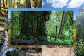
The hike: This gorgeous ramble through redwoods begins by following Alice Eastwood Road, a paved route closed to vehicles. Alice Eastwood Group Campground has picnic tables and portable toilets.
From the camp, take a sign-marked connector trail to Bootjack Trail, which descends west along lovely Redwood Creek. The path climbs, quite steeply in places, to tiny Van Wyck Meadow, then to the Pantoll ranger station.
At this point, sign-marked Steep Ravine Trail heads south, following switchbacks down through redwood, Douglas fir and huckleberry. After half a mile, the trail reaches Webb Creek and begins descending Steep Ravine.
Wood ferns, sword ferns and five-finger ferns line the trail. Climb down a ladder, built by the Civilian Conservation Corps in the 1930s, and cross a couple of footbridges.
About 1 1/2 miles from the trail head, Steep Ravine Trail is joined by the Dipsea Trail, coming from the east over a footbridge. Most hikers choose to keep right on Dipsea and head for the town of Stinson Beach.
The trail ends near the junction of Panoramic Highway and Highway 1 (Shoreline Highway). Follow the latter to Stinson Beach’s fine restaurants, its sand strand with picnic ground nearby and the bus stop.
*
For more of John McKinney’s tips, visit www.thetrailmaster.com.
More to Read
Sign up for The Wild
We’ll help you find the best places to hike, bike and run, as well as the perfect silent spots for meditation and yoga.
You may occasionally receive promotional content from the Los Angeles Times.


