Seals and Surf at Rincon Beach
- Share via
For surfers, the Rincon means Rincon Point near Carpinteria, one of the best places to surf on the California coast. East of the point, surfers catch the swells around the point and ride them near-parallel to shore. Waves break here in a foamy maelstrom.
For hikers, the route up the coast runs past a county park, a seal sanctuary and a state beach. This hike starts at Rincon Point, a sweeping spur into the ocean at the end of Rincon Creek, which divides Santa Barbara and Ventura counties.
The creek isn’t long, but it descends precipitously from the hills and, at flood stage, carries boulders toward the ocean. The rocks accumulate to form the spur of the point.
Up the coast lies Santa Barbara County’s Rincon Beach Park. In 1974, when beachgoers heard that the park was slated for concrete paving and other “improvements,” they staged a sit-in to protest. Officials were persuaded to pave less and preserve more. Today the park consists of small picnic grounds, a parking area and a path to the beach.
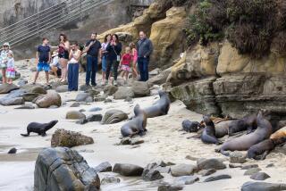
From December through May most years, you can spot seals from the bluffs on a short stretch of shore by the Chevron pier. Near this seal preserve are two more engaging destinations: the recently preserved Carpinteria Bluffs, where tranquil trails run through eucalyptus groves and across meadows, and All American Surf Dog, near the Bailard Avenue exit off U.S. 101.
All American Surf Dog proprietor Bill Connell, a colorful character, mans his mobile food stand from about 11 a.m. to 6 p.m. daily.
You can’t miss Connell’s bright red cart, topped by a hot dog sign and a large American flag. Customers--hikers, surfers, business professionals, bus drivers--savor the view of mountains on one side, the ocean on the other.
Directions to the trail head: From U.S. 101 about 12 miles north of Ventura, exit onto Bates Road. Drive briefly south to the beach and the parking area for Rincon Point.
The hike: Walk down toward the coast, with the freeway on your left and a line of eucalyptus trees on your right. Walk up the coast (toward Carpinteria and Santa Barbara) over the cobblestone path, passing beachfront homes.
Pause to watch surfers work the point, then cross the mouth of Rincon Creek. You will round Rincon Point on the cobblestone beach, pass the stairway up to Rincon Beach Park and reach the strand.
Your walk parallels railroad tracks, which are close. A mile and a half of walking leads to the pier. Join the trail that ascends the bluffs to a viewpoint above the seal preserve. (Walking along the beach into the preserve is forbidden when the seals are present.)
To explore the Carpinteria Bluffs, leave the vista point above the seal preserve, step across the railroad tracks and join a wide path that leads down the coast, back toward Rincon. The path splits: One branch turns inland to the end of Bailard Avenue and the All American Surf Dog stand, while the other travels a half mile across the bluffs before ending at an office park.
To reach Carpinteria State Beach, skip the Carpinteria Bluffs route and, from the seal viewpoint, continue on the trail up the coast (toward Santa Barbara). The bluffs are lower, the beach is wider, and you can improvise a route to the popular state beach and campground.
*
For more of John McKinney’s tips, visit www.thetrailmaster.com.
More to Read
Sign up for The Wild
We’ll help you find the best places to hike, bike and run, as well as the perfect silent spots for meditation and yoga.
You may occasionally receive promotional content from the Los Angeles Times.


