Big Muddy’s Present Is a Pale Reflection of Its Pioneer Past
- Share via
Lewis and Clark fought a muddy nightmare of swift currents, snags and sandbars to fulfill a young nation’s manifest destiny.
The Missouri River, their route to the Pacific in 1803, seemed intent on halting America’s expansion. It grounded their keelboat and swamped canoes. It slowed the expedition’s westward progress to a snail’s pace and, two years later, swept the explorers back to St. Louis with shocking speed.
“I sometimes wonder that some of our canoes or pirogues are not swallowed up,” Meriwether Lewis wrote.
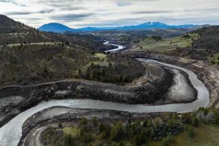
Nearly two centuries later, Americans still fight the river. But now we have the upper hand. From sea to shining sea, America is a skein of freeways, and the Big Muddy is dammed, ditched and diked from Montana to Missouri.
Last month, the conservation group American Rivers declared the Missouri the nation’s most endangered river, saying it is failing to reach its full potential for recreation, wildlife and other uses.
Shackled by levees and dams, hampered by agricultural interests and commercial barge navigation, the river is a shadow of its former self, the group said.
“It should be a national embarrassment,” said Scott Faber, a policy analyst with the group.
The Missouri isn’t even a river anymore, environmentalists protest, but a long, featureless channel almost devoid of native plants and wildlife. They want to see the Missouri that used to be, the “river that . . . tumbles, slides, meanders, sidesteps and plays leapfrog,” as one scribe described it in 1907.
In naming the Big Muddy America’s most endangered river, American Rivers put it above some real environmental nightmares.
The Missouri beat the Hudson, a New York river more severely contaminated with toxic PCBs in some spots than any other site in the country. It came in ahead of the Potomac, where an explosion of poultry farming in the upper basin and suburban development near Washington threaten both water quality and scenery. It even beat the Colorado, a river nearly sucked dry by thirsty Southwestern cities.
The Missouri’s prominence on the American Rivers list is partly due to politics, Faber explained. The U.S. Army Corps of Engineers, a government agency charged with maintaining the nation’s navigable waterways, is in the midst of reviewing how it manages the Missouri. American Rivers and other environmentalists hope to persuade the Corps to give a bit of the river back to Mother Nature.
“It’s probably the last time, at least in our lifetimes, that we will have a shot at thinking about how those dams are operated,” he said.
Faber and other environmentalists want to see an end to commercial barge navigation on the Missouri, a $15-million- to $20-million-a-year business that they contend pales next to the river’s recreational and environmental value.
By maintaining a channel for barge traffic below Sioux City, Iowa, and regulating the river’s flow in an unnatural way, they contend the Corps of Engineers is crippling one of America’s legendary waterways and wasting tax dollars doing it.
“Barge navigation is the most heavily subsidized form of transportation,” Faber said. “They’re giving corn a free ride to Mexico on our dime.”
But plenty of people living along the Missouri River would disagree.
“Navigation is an easy target for the people wanting to restore the river to Daniel Boone days,” said Paul Davis, who makes his living on the river as manager of Interstate Marine Terminals in Boonville, Mo. “If those reservoirs weren’t there, the lower river flooding that would ensue just would be incredible.”
Even with the dams, the flooding has been impressive. Since the end of World War II, the river has had six once-in-a-century floods.
On the Missouri, Daniel Boone days ended near the close of World War II, when the Franklin D. Roosevelt administration proposed damming and channelizing the river to provide jobs for returning GIs and, at the same time, turn the Upper Midwest into a breadbasket. Water from reservoirs on the Missouri would irrigate grain fields in the Dakotas, and the crops would move downriver on barges.
Though there were questions about the flood-control value of dams and some skepticism about the navigational value, the government went ahead and turned a river that once was described as “a tawny, restless, brawling flood” into an agent of man.
The Bureau of Reclamation put five dams on the river in North and South Dakota, and the Corps of Engineers dredged a deep, navigable channel from Sioux City to St. Louis.
The spring snowmelt that once barreled across the Upper Midwest now piles up behind six dams stretching from Fort Peck in Montana to Gavins Point in South Dakota. As things dry up in the summer, the Corps releases that reservoir water to keep flows high enough for the barges.
Much has been lost in harnessing the Missouri for human purposes. Three native species--the pallid sturgeon, the piping plover and the least tern--now reside on the federal endangered species list. Several more species are candidates for endangered status. Most of the river’s natural character--the sloughs, oxbows, sandbars and backwaters--has been lost to a deep, swift-flowing channel.
But something has been gained, too, by harnessing the Missouri. The reservoirs on its upper reaches have become popular places for fishing and boating. And farmers on the lower part of the river can grow crops in places where an unkept river would constantly flood them out and prevent their fields from draining in the spring.
The farmers are especially opposed to ending navigation, but not because they ship their grain on the river--less than 1% of all the grain grown in Nebraska, Iowa, Missouri and Kansas is shipped by Missouri River barge.
The farmers are against ending navigation because the same things that benefit barge operators--a steady flow of water in a well-controlled channel--benefit farming along the Missouri as well.
“It’s the farms that are the weak fellows in the structure,” protests Bill Lay, a farmer in Fayette, Mo. After the 1993 flood ruined his farm, he sold most of his land to the federal government.
The government has turned Lay’s land and several other parcels into the Big Muddy Wildlife Refuge, which now comprises 4,000 acres and eventually is expected to total 60,000 acres in 25 riverside parcels. Refuge manager J.C. Bryant calls them a “string of beads” that will rejuvenate some of the river’s natural habitat and relieve flooding downstream.
Founded after the 1993 flood, the refuge buys flood-damaged farmland from willing sellers only, Bryant says.
But willingness is a relative term when your land is covered with 10 feet of coarse sand, Lay notes.
“They’re trying to force us to sell by putting these damn big floods on us,” he says. “They keep flooding you out, you’re going to have plenty of willing sellers out there.”
More to Read
Sign up for Essential California
The most important California stories and recommendations in your inbox every morning.
You may occasionally receive promotional content from the Los Angeles Times.


