Trail from 1800s a Gold Mine for Hikers : Little known and out of the way, the Murietta Road northeast of Ojai is a scenic challenge for both hikers and bikers.
- Share via
Hiking and biking the backcountry around Ojai in the summer can be a blistering hot experience, but during the cooler winter months, the trails can be downright balmy.
Here’s one that most hikers and mountain bikers don’t know about: Murietta Road, located on the edge of the Matilija Wilderness in Matilija Canyon.
It doesn’t get nearly as much traffic as the popular Matilija Canyon trail nearby, but it’s both challenging and scenic. Its destination is a spot along the ridge that divides Ventura and Santa Barbara counties.
Water on one side of the divide flows into the Santa Ynez watershed in Santa Barbara County. On the other side, it flows into the Matilija watershed that feeds Lake Casitas and the Ventura River.
You won’t see many people on the divide, but it was people who gave it its colorful history. It’s most likely named after the Mexican outlaw Joaquin Murietta, whose real or legendary exploits made him notorious in Southern California during the mid-1800s.
The route over the mountains is basically the same one used during the 1800s by miners who trekked from Santa Barbara down through Matilija Canyon to work the gold fields near Piru, according to John Boggs, Ojai recreation technician for the Los Padres National Forest.
*
Now it’s a fire road. It draws a few hikers, horseback riders and mountain bikers, but it’s often possible to make the 10-mile round trip to the divide and see nobody else.
To get to the trail head, take Highway 33 north out of Ojai and turn onto Matilija Canyon Road. It’s a pretty five-mile drive, past Matilija Reservoir, along the wide rocky creek and through the cluster of tree-shaded small homes.
After you park and pass through the gate, you’ll walk along a dirt road past the Matilija Canyon Ranch and a few other homes. Bring some change and you can stop at the venerable fruit stand that has replenished many a hiker. A chalk sign advertises the produce: oranges, apples, lemons, grapefruit, tangerines. The honor system rules; your money goes in the metal box. If you take a walking stick from the pile, bring it back.
Watch out for peacocks along the road. One of the ranchers here raises them. Within a mile, you’ll see the turnoff for the Matilija Canyon Trail on the right. Don’t take it. A little farther you’ll see the Murietta Trail on the left. Don’t take that either; it goes to a campground about half a mile in.
Keep going on the road until you see the sign: “All trails.” Take it to the left and switchback up the north side of Murietta Canyon. At this point the climb is gentle and the road fairly smooth for biking.
The road, which in some places is no more than six feet wide, follows the rim of the canyon up. Water runs through here year-round, and for much of this trek you’ll hear it--everything from a trickle to a roar. In water-soaked places along the trail, you’ll see ferns.
*
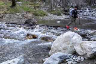
But the trees--oaks, sycamores, alders, and the big-leaf maple with its reddish leaves--make this such a nice route. They fill the bottom of the canyon and line the trail. About halfway up, you’ll come to a boulder-strewn stream crossing--a good spot for a breather, because you’ll need your strength.
From about this point, the road gets steeper, rockier and more rutted. Bikers will find it tough going. The last mile is a bit of a gut-buster. Once you reach the divide, there’s no sign or plaque to signify you’ve made it. It’s kind of a notch in the mountain ridge. But it’s an open, flat and pleasant, though breezy, spot to take in the view.
The elevation at this spot is 3,448 feet--a climb of about 1,800 feet from the trail head. Divide Peak, just to the south, is 4,707 feet. Although you’ll be turning around at the divide, the road continues down Juncal Canyon to Jameson Lake, above Carpinteria, and beyond.
DETAILS
* WHAT: Murietta Road to Murietta Divide, 10 miles round trip.
* WHERE: Trail head is at the end of Matilija Canyon Road, northwest of Ojai. From Ventura, take Highway 33 to Ojai. When it splits with Highway 150 in Ojai, continue on Highway 33 for 6.4 miles. Turn left onto Matilija Canyon Road. (It’s unmarked; look for mailboxes. It’s paved, climbs sharply.) Drive five miles to the trail head.
* FYI: Los Padres National Forest, 1190 E. Ojai Avenue, Ojai; 646-4348. Maps available here.
* ETC: Bring water. During winter, the days are shorter and at night the temperature can dip to freezing. Bring heavy clothing. Mountain bikes are not allowed in the Matilija Wilderness area, which includes the Matilija Canyon Trail, but they are permitted on the Murietta Road, which borders the area.
More to Read
Sign up for The Wild
We’ll help you find the best places to hike, bike and run, as well as the perfect silent spots for meditation and yoga.
You may occasionally receive promotional content from the Los Angeles Times.


