CULTURE WATCH : The Fault Is Not the Highway’s
- Share via
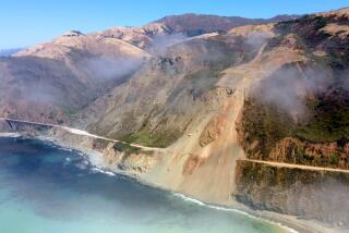
Except for occasional traffic snarls, commuters used to zoom past the interchange of California 14 and Interstate 5 with no reason to notice the rugged notch where two freeways and two mountain ranges meet. But before dawn on Jan. 17, the Santa Susanna Mountains rose more than a foot, reminding us that earthquake faults lie beneath the area, too.
Two centuries ago when Spanish and Mexican colonists traveled north out of the San Fernando Valley, they followed a Chumash trail. It followed a pass to Santa Clarita Valley that was below 2,000 feet in elevation but narrow, windy and steep--a maze of deep canyons.
The first wagon road using Beale’s Cut, a 250-foot-long, 90-foot-deep passage, to conquer the final ridge was not completed until 1862. The first highway to Gorman and beyond was not completely paved until 1919. The speed limit along parts of “the ridge route” was 15 m.p.h.
In 1934, the two-lane California 99 was widened to four lanes and divided by 1953. Finally, Interstate 5 was built between 1965 and 1970.
Now, since the quake, Santa Clarita and Antelope Valley commuters have had plenty of time to ponder the rugged nature of the pass as they creep along the four-lane, undivided Sierra Highway.
In the same capricious way a megalopolis sprang from a semi-desert prone to drought, fire, flood and earthquakes, Newhall Pass is a heck of a place to put a superhighway--fault lines are one of the main things that create mountain passes.
More to Read
Sign up for Essential California
The most important California stories and recommendations in your inbox every morning.
You may occasionally receive promotional content from the Los Angeles Times.


