Fortynine Palms Oasis Is Paradise
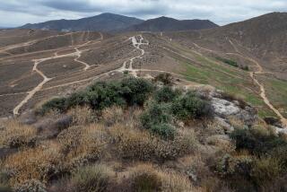
Fortynine Palms Oasis, protected within Joshua Tree National Monument and reached only by trail, has retained a wonderful air of remoteness. From the parking area, an old Indian trail climbs a steep ridge and offers the hiker expansive views of the Sheephole and Bullion mountain ranges. On the exposed ridge, barrel cacti, creosote, yucca and brittlebush brave the heat. As the trail winds up and over a rocky crest, the restful green of the oasis comes into view.
At the oasis, nature’s personality abruptly changes, and the dry, sunbaked ridges give way to dripping springs, pools and the blessed shade of palms and cottonwoods.
Unlike some oases, which are strung out for miles along a stream, Fortynine Palms is a close-knit palm family centered around a generous supply of surface water. Seeps and springs fill numerous basins set among the rocks at different levels. Other basins are supplied by “rain” dripping from the upper levels. Mesquite and willow thrive alongside the palms. Singing house finches and croaking frogs provide a musical interlude.
Perched on a steep canyon wall, Fortynine Palms Oasis overlooks the town of Twentynine Palms, but its untouched beauty makes it seem a lot farther removed from civilization.
Directions to trailhead: From Interstate 10, a few miles east of the California 111 turnoff going to Palm Springs, bear north on California 62. After passing Yucca Valley, but before reaching the outskirts of Twentynine Palms, turn right on Canyon Road. (Hint: Look for an animal hospital at the corner of California 62 and Canyon Road.) Follow Canyon Road 1 3/4 miles to its end at a National Park Service parking area and the trailhead.
Joshua Tree National Monument’s Oasis Visitor Center, a few miles from the trailhead, offers maps, information and interpretive displays. To reach the center, continue east on California 62 through Twentynine Palms to Utah Trail (flashing yellow light). Turn right (south) on Utah Trail and look for the visitor center on the right, just south of National Monument Drive. Hours are 8 a.m.-5 p.m. daily. Information: (619) 367-7511.
The Hike: The trail rises through a spartan rockscape dotted with cacti and jojoba. After a brisk climb, catch your breath atop a ridge top and enjoy the view of Twentynine Palms and the surrounding desert.
You may notice colorful patches of lichen adhering to the rocks. Lichen, which conducts the business of life as a limited partnership of algae and fungi, is sensitive to air pollution; the health of this tiny plant is considered by some botanists to be realated to air quality. Contemplate the abstract impressionist patterns of the lichen, inhale the fresh air, then follow the trail as it descends from the ridge top.
The trail leads down slopes dotted with barrel cacti and mesquite. Soon the oasis comes into view. Lucky hikers may get a fleeting glimpse of bighorn sheep drinking from pools or gamboling over steep slopes.
As the path leads you to the palms, you’ll notice many fire-blackened tree trunks. The grove has burned several times since this land was set aside a half century ago and placed under the protection of the National Park Service.
Fortunately, palms are among the most fireproof trees and fire, whether caused by man or lightning, seldom kills them. Fire may be beneficial for the palms, because it serves to temporarily eliminate the competition of such trees as mesquite and cottonwood, all of them thirsty fellows and able to push their roots much deeper in search of water than palms. Burning also opens the oasis floor to sunlight, which seedling palms need.
Fortynine Palms Oasis celebrates life. Washingtonia filifera , our native California fan palm, clusters near handsome boulder-lined pools. Fuzzy cattails, ferns and grasses sway in the breeze. An oasis gives the hiker a chance to view the desert in terms that are the exact opposite of its stereotypical dry hostility.
Fortynine Palms Trail
Parking Area to Fortynine Palms Oasis: three miles round trip; 400-foot elevation gain
More to Read
Sign up for The Wild
We’ll help you find the best places to hike, bike and run, as well as the perfect silent spots for meditation and yoga.
You may occasionally receive promotional content from the Los Angeles Times.


