Crystalline Views in Anza-Borrego Park
- Share via
More than half a million acres of California desert are preserved in Anza-Borrego Desert State Park, which includes virtually every feature visitors associate with a desert--washes, badlands, mesas, palm oases and a thousand more.
The park is vehicle-oriented; most of the popular scenic attractions can be reached by some semblance of a road. Still, desert day hikers have some extraordinary terrain at their feet. One of my favorite state park trails leads to the weird rock formations in Calcite Canyon.
Nature’s cutting tools, wind and water, have shaped the ageless sandstone in Calcite Canyon into steep, bizarre formations. The cutting and polishing of the uplifted rock mass has exposed calcite crystals. Calcite is a common enough carbonate, found in many rocks, but only in a few places are the crystals so pure.
It was the existence of these crystals, with their unique refractive properties, that first brought man to this part of the desert. A jeep trail was built in the mid-1930s for miners. The calcite crystals (used during World War II in making bombsights) were taken from the canyon in long trenches, which look as if they were made yesterday. The desert takes a long time to heal.
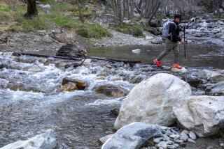
This day hike takes the jeep road to its dead end at the mine. You’ll see the calcite mine area up close and get a good overlook of the many washes snaking toward the Salton Sea. A return trip through Palm Wash and its tributaries lets you squeeze between perpendicular sandstone walls and gives a unique perspective on the forces that sculpt the desert sands. The awesome effects of flash flooding are easily discerned by the hiker, and suggest that a narrow wash is the last place in the world you want to be in a rainstorm.
Directions to trailhead: Follow County Road S-22 west from California 86 to Calcite Jeep Road (really the trail). Or, if coming from the east, it’s about 20 miles from the community of Borrego Springs to Calcite Jeep Road, which lies just west of a microwave tower.
The hike: Follow the jeep road, which first drops into the south fork of Palm Wash, then begins to climb northwest. Along the road you’ll see long, man-made slots cut into hillsides for the removal of calcite. The road dips a final time then climbs the last half a mile toward the mine. Two miles from the trailhead, the road ends at the mining area.
Calcite crystal fragments embedded in the canyon walls and scattered on the desert floor glitter in the sun. Behind the mining area, to the northeast, is a huge hunk of white sandstone dubbed Locomotive Rock. The imaginative can picture a great Baldwin locomotive chugging up a steep grade. If you look carefully, you’ll be able to see Seventeen Palms, and some of the palms tucked away in Palm Wash, in a bird’s-eye view of the east side of the state park.
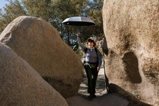
You can return the same way or descend through tributaries of the middle fork of Palm Wash. Take a last look at the steep ravine and washes to get your bearing. Middle Fork is but a hop, skip and a jump from the mine, but that jump’s a killer--a 50-foot plunge to a deep intersecting wash. To get into the wash safely, you need to descend half a mile down Calcite Road to a small tributary wash. Descend this wash, which is fairly steep at first. The sandstone walls close in on you. One place, “Fat Man’s Misery,” allows only one football player the size of William “The Refrigerator” Perry (or two skinny day hikers) to squeeze through at a time. When you reach the middle fork, a prominent canyon, follow it about one-fourth mile to the brief jeep trail connecting the wash to Calcite Road. Hike back up Calcite Road 200 yards to the parking area.
Calcite Canyon Trail
County Road S-22 to Calcite Mine: four miles round trip; 500-foot elevation gain.
More to Read
Sign up for The Wild
We’ll help you find the best places to hike, bike and run, as well as the perfect silent spots for meditation and yoga.
You may occasionally receive promotional content from the Los Angeles Times.


